5
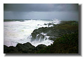
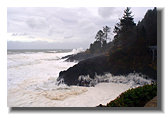
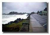
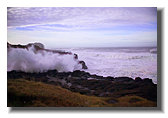
On 2-6-06 conditions were monumental. The offshore buoys were recording 42 foot swells and the windspeed was 65 kts, HURRICANE FORCE! I left Eugene at 6 AM, drove through lightning and pavement-covering hail, dodging downed limbs and trees and racing ahead of an imminent 55 mile constuction detour. When I first glimpsed the surf I was disappointed. I should have been there 3 hours earlier at 4 AM, high tide. You can't have a 42 foot wave in ten feet of water and by first light it was midway through the outgoing. The Pacific coast storms are short, intensive fronts, often over in hours. It is only IF the peak of conditions strike at high tide that the remnant waves, after successive breaking in the shallowing coast, can hit with serious intensity. The coast, after all, has been doing this for a long time. And it can be seen only in daylight. And then one has to shield the camera from continuous, drenching sheets of salt spray.
But at 8 AM the evidence of the conditions 3 hours earlier was everywhere. The parking lot 100 feet above sea level was totally flooded, drenched and covered with logs, rocks, kelp and sea foam.
6
7
8
9