Oregon Coast Storms
While the North Pacific is not THE most violent of oceans (the south Pacific circulating around the globe south of Australia, interrupted only by the southern spike of South America takes that honor) it makes up in quantity what it may lack in rare ultra-violence. There are more storms circulating almost continuously east to west in the jet stream creating the Japanese Current during the winter than in any other ocean. The endless winter gloom and drizzle of the Northwest, if not the actual rainfall, is legendary. In some of the micro-climates of the coastal river valleys the winter rainfall can reach 200 inches. Not bad!.
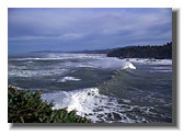
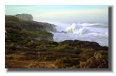
But the continuous onshore flow as well as the almost continuous storm tracks makes for a very inhospitable place if you want to be ON the water. In the winter the swell heigth is never below 10 feet and reaches 20 feet weekly, often for days at a time. As the fronts approach and cross the coast the wind regularly hits 50-60 mph sustained gusts and 100mph sweeping up over the headlands. Watching that interplay of fluid force hitting immovable coast is a sport all in itself. They call it storm watching. When the swells are predicted to be over 20 feet, the off-season motel vacancies fill up.
The best conditions are 1) morning, for a backlight sun, 2) a strong OFFSHORE wind (approaching front), 3) high tide, and 4) swells over 20 feet. Bright sunlight is too much to ask, but rarely....
These 5 shots are from Boiler Bay. 24 foot swells. 1-6-06.
Oh Yes. BE SAFE! 50 feet above the water is not enough. Every winter people are swept off by rogue waves. If you are on bare rock, it is bare FOR A REASON!
1
2
4