|
|
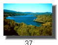
The Middle Fork of the Willamette has paid a high price for hosting the city of Eugene on it's banks. Unpredictable warm winter rains and 20 foot snowpack in the Cascades can make for some overwhelming flood events, which have buried downtown Eugene several times until the flood control dams were built. Virutally every tributary of the Willamette above Eugene with the exception of the North Fork of the Middle Fork has been dammed (and not for lack of trying there either), some several times. The main stem of the Middle Fork hosts two dams, Hills Creek just above Oakridge, and Lookout Point dam below Oakridge. The Lookout Point Dam/Dorena Reservoir and Lookout Point Lake complex has flooded a total of 20 miles of the mainstem Willamette, a significant loss. The middle Willamette River flows freely only between the Hills Creek and Lookout Point pool, and below Dorena through Eugene until it meets the McKenzie and becomes the valley floor Willamette. The other loss from the dams was the loss of salmon and steelhead access to upriver spawning grounds.
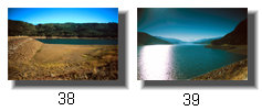
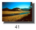
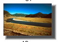
The good news is the Willamette no longer floods Eugene/Springfield, and the river flows even in summer are greatly stabilized. One can only dream about what those lost 20 miles of river and floodplain looked like. Every fall, though, as the reservoir is drawn down to lowest pool in preparation for winter rains, some of that river emerges at the upstream end as the pool recedes.
|